GEOTECHNICALENGINEERING
GILBERT
HomeGeophysicsElectrical resistivity / VES (Vertical Electrical Sounding)

Electrical Resistivity Testing for Subsurface Exploration in Gilbert, AZ

Geotechnical engineering with regional judgment.

LEARN MORE

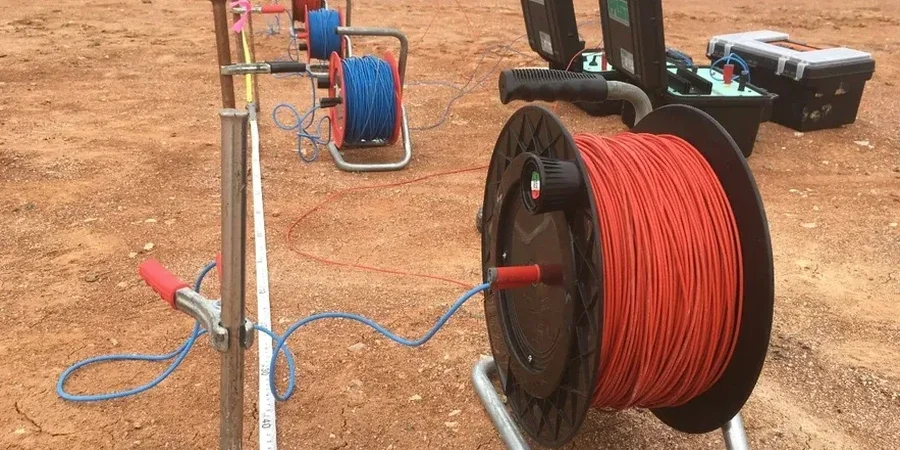
You can’t always tell what’s underground in Gilbert just by looking at the surface. A lot of folks assume the soil here is uniform desert fill, but that’s rarely the case. The valley floor hides irregular caliche lenses, old river channel deposits from the Salt River’s historical meanders, and pockets of expansive clay that can shift with monsoon moisture. When a standard borehole gives you data at one point, you’re still guessing what happens three feet to the left. That’s where electrical resistivity, specifically Vertical Electrical Sounding (VES), fills the gap. By injecting a controlled current into the ground and measuring how the subsurface resists it, we build a continuous profile of soil and rock layers. In Gilbert’s 110°F summer heat, this non-invasive method means we can map a half-acre lot in a few hours without trenching through someone’s landscaping or waiting on utility locates for every line. We often pair a VES survey with targeted test pits to calibrate resistivity values against visible soil texture, giving you a cross-checked dataset before you pour a foundation or design a retention basin.

Electrical resistivity doesn’t just find water or clay—it reveals the subsurface architecture that controls foundation performance across Gilbert’s basin-and-range geology.

Our service areas

Our approach and scope

Gilbert’s Sonoran Desert setting creates a particular electrical signature underground. During the dry months from April through June, surface resistivity can spike so high that standard electrode coupling becomes finicky—you learn to pre-wet the electrode holes or schedule the survey for early morning when residual soil moisture from irrigation gives better contact. Then come the monsoon storms in July and August, and suddenly the same lot will show a completely different shallow conductivity profile. Our technicians have run enough VES lines across the East Valley to know when a low-resistivity zone is just seasonal wetting versus a genuine clay layer that will swell under load. We follow the ASTM D6431 standard for field procedures, and when the data warrants it, we run a CPT test at a strategic point to confirm the resistivity layering with a physical penetration record. That combination is powerful for projects near the San Tan foothills or along the Loop 202 corridor, where subsurface transitions between basin fill and weathered granite can catch engineers off guard. The VES method resolves these boundaries at depths from a few feet down to over 100 feet, depending on the electrode spread, and the results integrate naturally into geotechnical reports prepared under IBC Chapter 18 requirements.
Electrical Resistivity Testing for Subsurface Exploration in Gilbert, AZ
Technical reference — Gilbert

Local geotechnical context

Gilbert sits at roughly 1,200 feet elevation on the eastern edge of the Phoenix basin, a spot where the groundwater table has been dropping for decades due to agricultural and municipal pumping. A VES survey from 1995 that showed saturated soil at 40 feet might read dry down to 80 feet today—and that change matters for anyone designing deep foundations or infiltration galleries. Caliche layers are another local wildcard. This naturally cemented calcium carbonate can form in discontinuous ledges that mimic bedrock on a resistivity profile but dissolve or fracture unpredictably when excavated. Misreading a caliche lens as competent bearing stratum has led to differential settlement problems in more than one Gilbert commercial building. The VES method helps map the lateral continuity of these layers, so you can decide before breaking ground whether the caliche is thick enough to support a shallow footing system or just a thin crust over weaker alluvium. For projects in the Heritage District, where older utilities and undocumented fill complicate the picture, resistivity also flags buried metallic objects and saturated zones that could signal a leaking water line—issues that a standard soil boring might miss entirely.

Need a geotechnical assessment?

Reply within 24h.

Email: info@geotechnicalengineering.sbs

Applicable standards

ASTM D6431-18: Standard Guide for Using the Direct Current Resistivity Method for Subsurface Site Characterization, IBC Chapter 18 (Soils and Foundations) – foundation investigation requirements, ASCE 7-22 Minimum Design Loads – geotechnical site class determination, ASTM D2487: Unified Soil Classification System (for correlating resistivity with soil type)

Technical parameters

ParameterTypical value
Method standardASTM D6431-18 (Resistivity imaging and sounding)
Typical electrode arraySchlumberger (VES) or Wenner (profiling)
Depth of investigationUp to 150 ft with expanded spreads
Measured parameterApparent resistivity (Ohm-m), inverted to true resistivity layers
Typical Gilbert soil resistivity range15–80 Ohm-m (clays/silts) to 500–2000+ Ohm-m (dry sand/caliche)
Reporting deliverable1D VES curves, 2D resistivity pseudosections, geotechnical cross-sections
Field deployment time1–3 hours for a standard VES sounding
Calibration referenceCorrelated with borehole logs or dynamic cone penetrometer data

Questions and answers

How much does a VES survey cost for a typical Gilbert residential lot?

For a standard half-acre residential parcel in Gilbert, a VES survey with two to three soundings and a basic report typically runs between US$610 and US$1,060. The final cost depends on how many sounding points you need, the electrode spread length required to reach your depth of interest, and whether we’re correlating the results with existing borehole data or running additional lines for 2D imaging.

How deep can electrical resistivity testing see in Gilbert’s desert soils?

With a Schlumberger array using a maximum current electrode spacing of 300 to 400 feet, we can typically investigate to depths of 100 to 150 feet. The actual depth of penetration depends on the subsurface resistivity contrast—dry sand and caliche above the water table allow deeper current penetration than saturated clay, which tends to shunt current near the surface. We design the electrode spread for each site based on the target depth in your geotechnical scope.

Does the VES method work if the ground is very dry or has a lot of caliche?

Dry ground and caliche both present high contact resistance at the electrode-soil interface, which can degrade data quality if not managed properly. Our field crew addresses this by pre-soaking electrode holes, using bentonite slurry around the stakes when necessary, and taking multiple readings to check repeatability. Caliche layers themselves are actually a good resistivity target—they stand out as high-resistivity zones against surrounding alluvium, so they’re easier to map than you might expect.

Location and service area

We serve projects in Gilbert and surrounding areas.

View larger map